Background
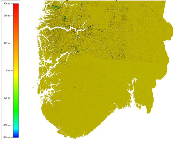
Today, there are challenges in the current processing of Sentinel-2 satellite images delivered by ESA in terms of geometric performance (distributed in e.g. ESAs Open Access Hub). When Copernicus started producing and distribute Sentinel-2 MSI L1C products, the NOrwegian Space Agency (NOSA) and the Norwegian Mapping Authority initiated a project verifying the performance of these products over Norwegian areas of interest. The conclusion was that the Digital Elevation Model (DEM, PlanetDEM 90) used by ESA when orthorectifying these products did not perform sufficiently above 60 degrees latitude, see figure below. The main problem is that horizontal errors in the DEM propagates into vertical errors in the satellite image. The entire report can be read here.
Sentinel-2 DTERRENGDATA
As a Copernicus member state, NOSA requested ESA on behalf of the Norwegian user community to start orthorectifying Sentinel-2 data using national DEMs (over mainland Norway and Svalbard). The result was that ESA started processing Sentinel-2 L1C products as a separate, national deliverable with the Norwegian DSM 10 over Norwegian mainland and the 20m DEM over the Svalbard archipelago provided by The Norwegian Mapping Authority and The Norwegian Polar Institute respectively. The production and dissemination of these products, denoted with the suffix DTERRENGDATA, started August 2017. These products are only available in colhub.met.no in SAFE and as NetCDF/CF in the integrated search interface (National hub).
For the users, there are however some challenges:
1. We have experienced periods where Sentinel-2 products with national DEM has not been processed. I.e. for some products, users will find the regular Sentinel-2 product but not the Sentinel-2 product with the suffix DTERRENGDATA. Since this is not an operational deliverable from ESA, we can not push on-demand processing for these products. However, we can every now and then provide them with a list of products or a period of time when DTERRENGDATA products are not available. Hence, if there are some products you do not find, please use the contact form and provide us with the information concerning the products not found and we will forward the list of products missing when the list as reached a certain size.
2. The DTERRENGDATA products does not match the layout and/or content of the regular Sentinel-2 L1C products. I.e. some standard ancillary information is missing like the manifest.safe and cloud information. In addition, the baseline processing of these products is lower than the current baseline for the regular Sentinel-2 L1C products i.e. 202 and not 208.
3. Due to the missing information in point 2, it is not possible to run the atmospheric correction tool Sen2Cor on these products. In other words, Sentinel-2 products processed with Norwegian DEMs is not available in Level-2A i.e. bottom of atmosphere reflectance values.
For any questions regarding these products, please use the contact form.